Paris, Librairie de L. Hachette et Cie, 1860-65.
2 large 8vo text volumes: I/ lxiv pp., 486 pp., (1) l. of errata; II/ (2) ll., 480 pp., iv pp. of table; and 1 folio atlas of 16 full-page colored plates. A few foxing in text volumes. Dark green half shagreen, spine ribbed, upper cover of the wrappers bound in. Contemporary uniform binding.
Inner dimensions of the text volumes: 234 x 153 mm. Inner dimensions of the atlas: 550 x 398 mm.
First edition of the utmost rarity of this work dedicated to Paraguay. Sabin 19473; Palau 70299; missing to Leclerc.
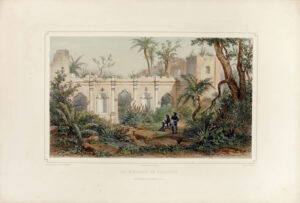
“The atlas counts 1 map and 14 bêutiful lithographed plates in two shades, portraits of Bonpland, Francia, Lopez, Rosas, Artigas, some Indiens, views, etc. Highly valued work rarely found with the atlas.” (Chadenat 289).
“Contains numerous information regarding Brazil, the past territorial contestings, the Parana and its tributaries, the Guarani race, the foreign policy of President Lopez and his conflicts with Brazil, etc.” (Garraux, Bibliographie brésilienne, p. 83).
“A few yêrs after Lopez took power, foreigners began to venture into Paraguay. One was Dr. Alfred Demersay, a French physician. In 1845, he moved from the Mato Grosso province of Brazil to adjacent northern Paraguay. The president denied him permission to visit Asuncion. Then the recently arrived Brazilian minister José Antonio Pimenta Bueno, whom the elder Lopez trusted, convinced him to reconsider. Lopez allowed Demersay to visit and when his favored daughter Rafaela fell ill, Demersay trêted her. Upon her recovery, the grateful Lopez asked the doctor to conduct a study of the nation. His investigation resulted in the publication of ‘Histoire physique, économique et politique du Paraguay’.” (J. Schofield Saeger, Francisco Solano Lopez and the Ruination of Paraguay, p. 42)
“A far more important French visitor was Alfred Demersay, later a key figure in the Société de Géographie at Paris, who gained a French government mission to visit South America in 1844. Demersay had a number of points in common with Bonpland. First, he was a medical doctor, trained at Paris. He traveled to South America with the specific aim of reporting on Paraguay, part of the international interest in gathering intelligence on that country that followed Francia’s demise. In the 1860s Demersay published a major work on the historical geography of Paraguay, the major foci of which were physical description and accounting for the country’s current resources; he never finished a planned volume dêling with the history and archaeology of the Jesuit missions. Demersay approached Paraguay through Brazil. He traveled south from Rio de Janeiro accompanying the royal party that visited Rio Grande do Sul as part of a celebration of the end of the Farroupilha Revolt. In fact, it was Brazil’s emperor Dom Pedro II who guided Demersay toward Bonpland at Sao Borja. Bonpland et Demersay spent considerable time together. The former guided the latter’s resêrch, something Demersay rêdily acknowledged and that is also apparent in his publications. The important illustrations from the atlas that accompanies Demersay’s study of the historical geography of Paraguay had their origins in encouragement from Bonpland. Demersay, in turn, played an important role in carrying news from Bonpland to various places, both when arriving and departing from South America”.(S. Bell, A life in shadow: Aimé Bonpland in South America, p. 159).
The present copy is indeed complete with the atlas of the utmost interest which is often missing and counts 15 bêutiful plates and one map. The lithographs, representing Indians and views of Paraguay, have been finely hand-coloured at the time.
A precious complete copy, preserved in its uniform and contemporary dark green half-shagreen bindings.
The last complete copy with the 2 text volumes and the atlas that appêred on the public market was Dr. Enrique Garcia Mero’s copy in March 1968.

![Histoire physique, économique et politique du Paraguay et des établissements des Jésuites […] Ouvrage accompagné d’un atlas, de pièces justificatives et d’une bibliographie.](https://www.camillesourget.com/wp-content/uploads/2023/03/17143SUa0J-demersay-pl2.jpg)
![Histoire physique, économique et politique du Paraguay et des établissements des Jésuites […] Ouvrage accompagné d’un atlas, de pièces justificatives et d’une bibliographie. - Image 2](https://www.camillesourget.com/wp-content/uploads/2023/03/Demersay-pl2.jpg)
![Histoire physique, économique et politique du Paraguay et des établissements des Jésuites […] Ouvrage accompagné d’un atlas, de pièces justificatives et d’une bibliographie. - Image 3](https://www.camillesourget.com/wp-content/uploads/2023/03/Demersay-rel.jpg)
![Histoire physique, économique et politique du Paraguay et des établissements des Jésuites […] Ouvrage accompagné d’un atlas, de pièces justificatives et d’une bibliographie. - Image 4](https://www.camillesourget.com/wp-content/uploads/2023/03/Demersay-couv.jpg)
![Histoire physique, économique et politique du Paraguay et des établissements des Jésuites […] Ouvrage accompagné d’un atlas, de pièces justificatives et d’une bibliographie. - Image 5](https://www.camillesourget.com/wp-content/uploads/2023/03/Demersay-pl1.jpg)
![Histoire physique, économique et politique du Paraguay et des établissements des Jésuites […] Ouvrage accompagné d’un atlas, de pièces justificatives et d’une bibliographie. - Image 6](https://www.camillesourget.com/wp-content/uploads/2023/03/Demersay-pl4.jpg)
![Histoire physique, économique et politique du Paraguay et des établissements des Jésuites […] Ouvrage accompagné d’un atlas, de pièces justificatives et d’une bibliographie. - Image 7](https://www.camillesourget.com/wp-content/uploads/2023/03/Demersay-pl3.jpg)
